
2023 © Maxim Tabachnik

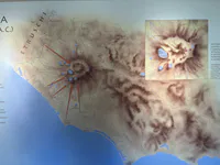
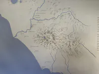


초기 라티움 중심지 지도
이 지도는 라티움 정착지들(기원전 11–9세기)을 보여 주며, 알바 롱가와 라비니움 같은 유적이 위치한 화산 지형의 알반 언덕을 중심으로 하고 있습니다. 이곳들은 고대 라티움의 문화적·정치적 핵심을 이루었으며, 서로 가까운 지리적 위치는 초기 철기 시대에 결속과 정체성을 강화하는 데 기여했습니다. 당시에는 지형이 권력과 신앙 모두를 이끄는 기준이 되었습니다.
인기 카테고리
광고 공간