
2023 © Maxim Tabachnik
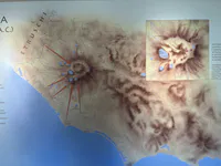


Map of Early Latial Centers
This map of Latial settlements (11th–9th cc. BC) centers on the volcanic Alban Hills, where sites such as Alba Longa and Lavinium formed the cultural and political core of ancient Latium. Their close geography fostered cohesion and identity in the early Iron Age, when topography guided both power and belief.
Explore by type and place